

Cuyahoga Valley National Park. Located just north of Akron, Cuyahoga is Ohio’s one claim to national park fame, and quite a good one at that. Established in 1974 as a national recreation area, Cuyahoga was finally recognized as a national park in the year 2000, making it one of the youngest in the country. Originally named “Kahyonhá:ke” by Native Americans, it loosely translates to “crooked river” or “twisted water”; quite an apt description for the wandering streams of the Cuyahoga River, though the name gives no hint of the river’s troubled history. Wedged between the industrial centers of Ohio, the river became so polluted that in 1961 the water itself actually caught on fire, sparking a major shift in environmental awareness, and leading to the preservation of the pristine setting we can enjoy today. Now, the 51 square miles of wilderness draw over two million visitors a year, and for good reason. One of the most diverse national parks ever to surface, Cuyahoga offers a wide variety of natural elements, from towering waterfalls and shattered limestone creek beds, to valley overlooks and winding bedrock caverns.
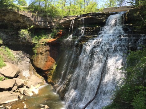
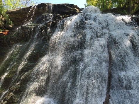
Upon entering the park, we were immediately enthralled by its visitor center, which unlike most national parks, takes the form of the historical Boston Store Village. A quaint reminder of when the river served as the primary, if not only, method of industrial transportation between the urban centers of Akron and Cleveland. Starting out from the village, the first thing you will come upon is the Towpath trail, a 21 mile path running along the then Erie Canal, and crossing through not only Cuyahoga but also a whole mess of other recreational areas and metroparks. If you set out on the trail, which is the primary pathway through the park, the first and perhaps most notable offshoot you will come across is the Stanford Trail, which leads to the magnificent Brandywine Falls. Over 60 feet of water falling across three million year old bedrock, bounding off each and every ancient ledge with a sort of chaotic grace. One of just many waterfalls located throughout the park, Brandywine is by far the largest, and one of the park’s main attractions. Walking up to the falls I felt almost taken aback that something like this was nestled away in the infinite forests of Ohio. The surrounding area never gave any indication it was hiding something of this magnitude, until we were right on top of it. The water runs down the bedrock with an almost palpable desire, yearning to begin its journey into the upper section of the Cuyahoga River, practically leaping off the jutting stones and down into the mayhem of earth and rock below. It has an almost hypnotizing effect, I found myself urging it on, even expecting to see the river start to rise in response to its eagerness, though of course it never did. Tearing my gaze away, I began to notice the rock itself, jagged and ancient, as though cut away viciously by some great being. The entire area gives a rare glimpse into the history of our very planet, and its teachings are accessible simply by looking at it. Staring at the facade from the winding boardwalk which straddles the river, you can see plain as day where the rock abruptly changes type and sediment, painting a picture of the cataclysmic forces once exerted upon the area. It was here that I realized why Cuyahoga is a national park, and why it deserved that title, granted so sparingly.
Upon leaving the falls our next destination was the Ledges, located a good deal south of the Boston Store, getting there can be a little confusing if you’re driving to the trail head, though still a tactic we would highly recommend. Cuyahoga, while not large to the point of being un-hikable, is broken up rather oddly by pieces of land not owned by the government, and therefore not “national” parts of the park. These pieces of land vary in type, from other parks, encompassed by Cuyahoga National but maintained by separate state and local agencies, to very strange clusters of private land; golf courses, highway-bridges, even some residential areas, making it something of a mystery in terms of navigation. Though hiking straight from trail to trail is technically possible, it’s been made an incredibly arduous process by this splicing up of the park, and driving to and from each trail head is by far the best way to see the park if you want to accomplish this in any reasonable amount of time. In fact, it was almost designed to be seen in this fashion, with nice groupings of trails centered around every major attraction, and individual trail maps (available at any visitor center), for each one. They even have sheets at each center with road directions to each area, something we found to be incredibly useful, if not essential, as many of the roads are sparsely marked and tucked away amidst the forest. That being said, even allowing for a little confusion the distance between attractions is fairly short, and most can be covered in less than 15 minutes (driving).
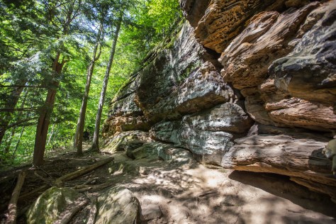
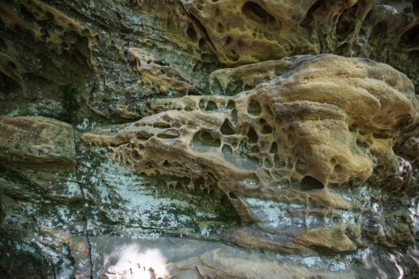
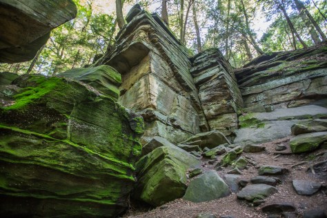
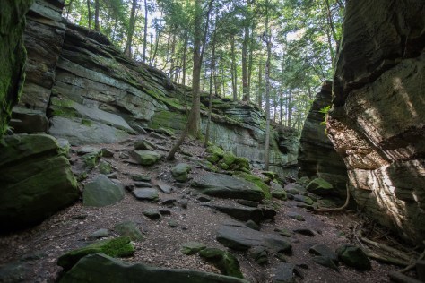
The Ledges are giant portions of exposed Sharon Conglomerate, a massive section of conglomerate rock which forms the base for most of Pennsylvania, and juts out into northern Ohio. Thus named for it’s location over the town of Sharon Pennsylvania, the Sharon is laid bare at it’s westerly edges in Cuyahoga valley, giving birth to an almost alien landscape. The primary trail through the Ledges, known as the 1 & 3/4 loop, takes you all the way around the edges of the Sharon and into the forest atop it, where you can find some impressive valley outlooks. The entire area is rife with massive outcroppings and cavernous ravines, turning what is technically a rather short hike into hours of potential exploration. The Ledges fall into two primary environments, a lower elevation area where the edge of the conglomerate is exposed beside you, and a higher elevation one where the forest sits atop gaping cracks and caves down into the rock. Our hike along the loop took us first to the lower area, and immediately I was reminded of Cuyahoga’s nationally bestowed status. The Sharon is like a gigantic living being, a fungus, ever so slowly growing, bubbling outwards in every direction. It’s grasp extending out towards Ohio, it almost seems to strain itself, reaching desperately for more land to cover. The outcroppings, curiously finger like, bear the scars of this eternal struggle; great boulders laying all around their edges, the appendages crippled by years of unrelenting nature. Even the path shows signs of the Sharon’s fatal ambition, the rough dirt replaced by a layer of sand, a token left by the element’s gradual erosion of this soft sandstone giant. The raw power wielded by both forces, locked forever in the slowest battle you’ve ever seen, commands a certain respect from the minute you first lay eyes on it.
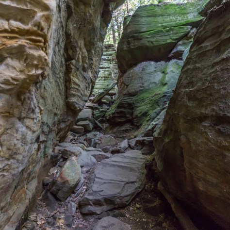
The other portion of the Ledges is just as, if not even more impressive. The densely forested area atop the ridge is populated with ravines some 60 feet deep, the veins running through the palm of this great beast. Created through a combination of wind, water, and man, the ravines extend throughout the center of the loop, doubling the amount of available trail and offering up some of the most unique hiking for hundreds of miles around. The primary trail down through the ravines begins just north of the Ice Box Cave, a place we found to be very deserving of its name. The cave houses a large majority of Cuyahoga’s bats, though unfortunately it is currently barred to the public due to the spread of white-nose syndrome, a fungal disease which is currently ravaging the local bat population. Nevertheless, it is still definitely worth a visit, as even the entrance is enough to show you where it got it’s rather telling moniker. Upon getting within about 10 feet of the cave mouth, the air suddenly dropped a staggering 30 degrees, and a chill seemed to seep from the blackness of it’s depths. For a cave to have this effect was startling to say the least, especially one that houses large populations of bats, who’s residual body heat and giant heaps of droppings generate considerable heat. This wall of cold could only mean that the cave extended far, far deeper than we had initially expected, though unfortunately we were left only to imagine. The rest of the path will take you along the edges of these ravine clusters, eventually leading back up to a point not far off from the 1 & 3/4 trail head. However, it is once you go off trail that you really get the full effect of these magnificent formations, great swathes of earth cut into a haphazard maze of rock and moss. As we wandered through, we became dwarfed by the twisting walls of stone, losing any perception we may have had as to where we were in relation to the trail. The temperature drops along with the terrain, and the towering walls of the ravines create an almost ghostly quiet. So vast is this expanse of narrow stone passages that it even has its own clearings, great pits devoid of rock save a few boulders, complete with trees and ferns, hidden away by the drapes of the earth. In this manner the inner Ledges continue for a good few square acres, remnants of the Sharon’s 300 million year old grasp on the valley.
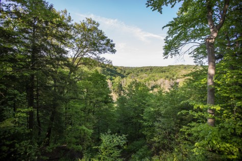
Our final destination of the day was the river itself, the spine of the valley, and lifeblood of the park. Though much of the river is quite striking and can be viewed from innumerable points throughout the park, we chose Tinkers Creek as our location, a large offshoot from the main river into the northernmost part of the park, and the largest tributary into the river itself, providing over a third of its flow. The vast majority of Tinkers Creek is actually a metropark, and is best accessed from the main roads through the area, however it is very well marked and definitely one of the most popular spots along the water. Resting nicely between the hills of the valley and the flat forest to its north, the Tinkers Creek area also offers some great overlooks and bluffs, many of which look down onto the water below, giving an idea of just how crooked the crooked river really is. The water flows low over the boulders which populate it’s bed, smoothing them to the point of reflection, and giving them an almost golden hue in the sunlight. It’s here that Cuyahoga feels much more park, and a lot less national. The scene down by Tinkers Creek simply isn’t complete without a good old American family barbecuing on the vast open lawns beside the bank, maybe somebody tossing a Frisbee to an overly excited golden retriever, and a lot full of cars gleaming in the sun not far away. The water is shallow enough in places to walk across the creek without so much as wetting your knees, barely even your ankles, and there are ample rocks to make a balancing act of crossing the water without getting wet at all. There are plenty of trails leading off from the main park areas along the river, most of them travelling through Tinkers Creek Gorge, the shell left behind by the ancient river that once followed this same path, carving incredibly dramatic slopes into the land around it. It’s a rewarding hike if you have the time, though the gorge is best viewed from the overlooks to the south, and the river itself is just as fulfilling to explore. Due to the water level dropping slowly over the years, much of the bed is exposed on both sides, allowing you to travel up and down the actual creek with a surprising amount of ease. We chose to stick to the water, and were rewarded for doing so with the shot featured at the top of the page. The riverbed is comprised of hundreds of layers of crushed limestone and shale, creating a silver metallic lining as the creek winds its way west towards the Cuyahoga.
Overall, Cuyahoga Valley and all its surrounding bits and pieces are definitely worthy of being a “national” park. Though it may not be the most grand or striking terrain when compared to the likes of Yosemite or Glacier, it offers some of the most unique and diverse environments you could ever hope to visit. While most all of the national parks are truly unique, few can give you such an intriguing look into what lies beneath the midwest, the secrets hidden under countless miles of foliage and squirrels. From above, the river seems to be all the area has to offer, but delve deeper and the forest peels back to reveal millions of years of history, trapped in stone. And best of all, its accessible. Its very accessible. With parking lots and shelters located near every major aspect, you could just as easily spend a day, or a few hours, and still manage to see the best of what this park has to offer. That being said, no man alive could see all of 51 square miles in a single day, and the park is diverse enough to keep you coming back for more. It’s more than just a place you put on a list of sights, somewhere you go once and then think back fondly on. It’s somewhere you think about taking your family next weekend, somewhere you can picture yourself relaxing on just any other average day, it’s a park. The best sort of park, the kind of park that can be surrounded by highways, railroads, and cities, but you’d never even know it.
